einstein (São Paulo). 25/nov/2025;23:eAO1826.
Smartphone-based retrospective analysis for malaria hotspot detection
DOI: 10.31744/einstein_journal/2025AO1826
Highlights
■ Patients gave informed consent to share GPS history from their smartphones.
■ Anonymized GPS data revealed stay points and malaria infection hotspots in Manaus.
■ Hotspots guided health agents to mosquito breeding sites, aiding malaria control.
ABSTRACT
Objective:
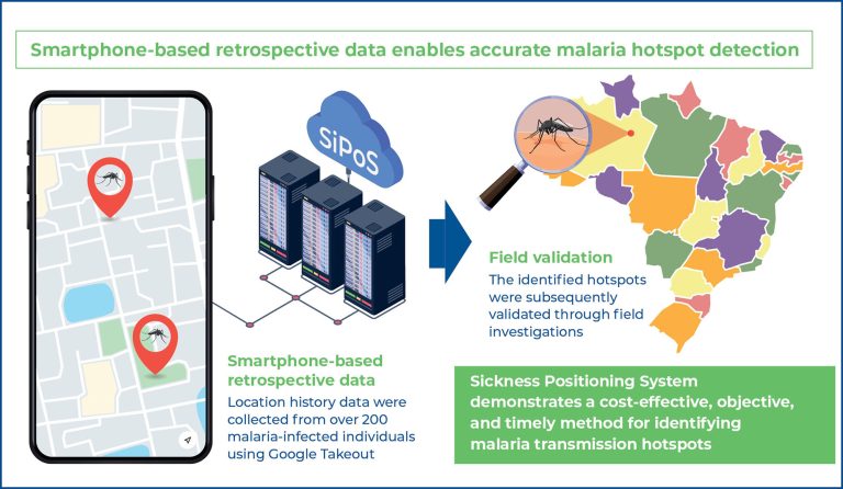
To leverage passively collected retrospective smartphone location data to accurately identify malaria transmission hotspots through the development of a novel tool, the Sickness Positioning System.
Methods:
We collected anonymized location history data from over 200 malaria-infected individuals using Google Takeout. Sickness Positioning System applies density-based clustering techniques to this passively collected data to identify areas of elevated infection risk. The identified hotspots were subsequently validated through field investigations.
Results:
Sickness Positioning System successfully pinpointed multiple areas of increased malaria transmission risk. Field validation confirmed two previously unrecognized mosquito breeding sites as active sources of transmission. When compared to Brazil’s federal surveillance system – which updates data annually – Sickness Positioning System provided a more precise and timely spatial assessment of malaria spread.
Conclusion:
Sickness Positioning System demonstrates a cost-effective, objective, and timely method for identifying malaria transmission hotspots. This approach has the potential to significantly enhance disease surveillance and facilitate more targeted public health interventions.
[…]
Palavras-chave: Malaria; Smartphones; GPS; SiPoS; Spatial analysis
168